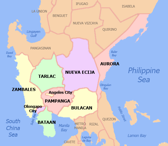
 Central Luzon (Region III) occupies the central portion of the island of Luzon and is strategically located between Northern Luzon and the National Capital Region. It is landlocked by Pangasinan and Nueva Vizcaya on the north; Metro Manila, Cavite and Rizal on the south; Aurora and Dingalan Bay on the east and Palauig Bay and Subic Bay on the west. It is bestowed with a combination of towering mountains, extinct and active volcanoes, lush verdant farmlands and natural sea harbors. It is the largest contiguous central plain in the country and the region is traditionally known as the Central Plains and Rice Granary of the Philippines. It consists of seven (7) provinces, namely, Aurora, Bataan, Bulacan, Nueva Ecija, Pampanga, Tarlac, and Zambales ; two (2) highly urbanized cities, 12 component cities, 20 Congressional Districts, 116 municipalities, and 3,102 barangays. Its regional administrative center – the City of San Fernando, Pampanga – is about 65 kilometers north of Metro Manila.
Central Luzon has a total land area of about 2.13 million hectares; some 1.11 million hectares (51.9 percent) are Alienable and Disposable lands while the remaining 1.02 million hectares (49.1 percent) are forest and unclassified lands of the public domain. An estimated 434.3 thousand hectares has been set aside for agri-industrialization and food security purposes based on the Strategic Agriculture and Fisheries Development Zones (SAFDZs) of the Bureau of Soils and Water Management (BSWM) of the Department of Agriculture. (Source: Central Luzon Regional Development Plan, 2017-2022).
Central Luzon lies at the heart of Luzon. It has the largest contiguous lowland in the Philippine Archipelago. Its total mass of 1.8 million or 18,230 square meters is 7.1 percent of the total land area of the country.
The prevailing landforms in the region is defined by a large basin surrounded by mountain ranges on three sides. On its northern boundary, the Caraballo and Sierra Madre mountains separate it from the provinces of Pangasinan and Nueva Vizcaya. The Sierra Madre mountain range traverses the length of Aurora, Nueva Ecija and Bulacan in the eastern section. At the western side, the Zambales mountains separates the central plains from the urban areas of Zambales.
Central Luzon serves as a vital link between the huge market in NCR and the resource-rich north Luzon. The major roads to the rest of North Luzon converge in Bulacan before entering Metro Manila.
Central Luzon is a major contributor to the Philippine economy. It accounted for 8.98 percent of the country’s Gross Domestic Product in 2013. GDP grew by 4.30 percent. Agriculture, Hunting, Forestry and Fishing sector comprised 16.97 percent of the regional economy and it was 5.37 percent in 2013.
Central Luzon contains the largest plain in the country with its agricultural plains accounting for about 40% of the region’s area. It produces most of the country’s rice supply, earning itself the nickname “Rice Bowl of the Philippines or Rice Granary of the Philippines”. Excess rice is delivered and imported to other provinces of the Philippines. Although rice is the major crop, its vast and fertile plains are highly suitable for growing almost all agricultural crops. It has long coast lines rich with marine fishing grounds in Bataan, Zambales and Aurora. About 45 percent of the region’s area is devoted to forestlands. Gold, silver, chromite, limestone, marble, clay, sand and gravel abound in either Zambales or Bulacan.
As a player in national development, its current level of development allows it to significantly contribute to the growth of the national economy. Central Luzon is fast recovering from the calamities it continues to experience. Reconstruction and development programs and projects since 1991 have enabled Region III not only to rehabilitate, but also to turn the calamity into an opportunity to achieve something better.
Despite the Pinatubo disaster, Cental Luzon can still boast of internationally competitive investment areas and facilities such as Clark and Subic economic zones. These special economic zones have been instrumental in putting the country and region back into the map of international affairs.
The population of Central Luzon in 1990 was 6.3 million. It increased to 8.2 million in 2000 to 10.1 million in 2010. Based on the mid-decade census of the Philippine Statistics Authority (PSA), the region’s population was 11.2 million in 2015. If the annual growth rate of 2.0 percent between 2010 and 2015 remains constant, Central Luzon’s population will double its 2015 figure in 34 years in the year 2049.
| 2018 | 2019 | 2020 | 2021 | 2022 | ||
| REGION 3 | 11,867,561 | 12,099,325 | 12,335,733 | 12,576,880 | 12,822,864 | |
| AURORA | 221,966 | 224,648 | 227,363 | 230,110 | 232,891 | |
| BATAAN | 804,530 | 820,173 | 836,120 | 852,378 | 868,951 | |
| 730,528 | ||||||
| CITY OF BALANGA | 101,602 | 103,578 | 105,592 | 107,645 | 109,738 | |
| BULACAN | 3,515,504 | 3,595,669 | 3,677,663 | 3,761,526 | 3,847,301 | |
| 2,521,161 | ||||||
| CITY OF MALOLOS | 269,182 | 275,321 | 281,599 | 288,020 | 294,588 | |
| CITY OF MEYCAUAYAN | 223,273 | 228,365 | 233,572 | 238,899 | 244,346 | |
| CITY OF SAN JOSE DEL MONTE | 613,052 | 627,032 | 641,331 | 655,955 | 670,913 | |
| NUEVA ECIJA | 2,268,553 | 2,310,210 | 2,352,632 | 2,395,834 | 2,439,829 | |
| 1,614,740 | ||||||
| CABANATUAN CITY | 318,680 | 324,532 | 330,491 | 336,560 | 342,740 | |
| CITY OF GAPAN | 116,306 | 118,442 | 120,617 | 122,832 | 125,087 | |
| PALAYAN CITY | 43,275 | 44,069 | 44,879 | 45,703 | 46,542 | |
| SAN JOSE CITY | 147,343 | 150,049 | 152,804 | 155,610 | 158,468 | |
| SCIENCE CITY OF MUÑOZ | 85,918 | 87,495 | 89,102 | 90,738 | 92,404 | |
| PAMPANGA | 2,772,276 | 2,830,386 | 2,889,715 | 2,950,288 | 3,012,130 | |
| 1,816,660 | ||||||
| ANGELES CITY | 437,270 | 446,436 | 455,794 | 465,348 | 475,102 | |
| CITY OF SAN FERNANDO | 325,757 | 332,586 | 339,557 | 346,675 | 353,942 | |
| MABALACAT CITY | 266,418 | 272,003 | 277,705 | 283,526 | 289,469 | |
| TARLAC | 1,420,364 | 1,439,516 | 1,458,926 | 1,478,598 | 1,498,535 | |
| 1,093,141 | ||||||
| CITY OF TARLAC | 356,117 | 360,918 | 365,785 | 370,717 | 375,716 | |
| ZAMBALES | 864,368 | 878,722 | 893,313 | 908,147 | 923,227 | |
| 640,636 | ||||||
| OLONGAPO CITY | 244,490 | 248,550 | 252,677 | 256,873 | 261,139 |
The proximity of Central Luzon, Metro Manila and CALABARZON to each other creates a natural synergy among the three regions. These three regions are sometimes referred to as Mega Manila, and the areas covered by distances of up to 100 kilometers from Manila City commonly called Greater Capital Region (GCR). GCR is a huge domestic market where two-thirds of the gross economic output is produced. It is also a compact urban agglomeration with a total population of 38.5 million (2 of 5 Filipinos live in GCR) with the highest income per capita.
Employment
Central Luzon’s labor market showed signs of improvement following the sustained positive gross domestic product (GDP) growth. An annual average of 100,000 new entrants joined the labor force reflecting optimism in the growing economic activities. Employment grew at an average of 2.6 percent with about 73,000 job being created annually.
Climate
Dry season in the Region is from November to May. Rains normally occur during the months of July to October.